Nonprofits face complex geographical challenges that impact operations, donor engagement, and volunteer coordination. With limited resources, they must make data-driven decisions to maximize their impact and serve as many constituents as possible. Without the right tools, it’s challenging to determine where to focus efforts most effectively in their CRM (Constituent Relationship Management).
RealZips empowers nonprofits to overcome geographical challenges, enabling smarter outreach, optimized resource allocation, and deeper community engagement—ultimately helping organizations fulfill their mission more effectively. By enriching Salesforce records such as constituents and households with geographic context, nonprofits gain deeper insights to refine fundraising strategies, enhance engagement, and allocate resources exactly where needed.
This blog explores eight key ways RealZips helps nonprofits streamline operations by automatically organizing constituents—supporters, volunteers, and beneficiaries—by chapters, regions, and service hubs. It also enhances efficiency through workflow automation and equips teams with trusted GeoData for smarter decision-making across these critical use cases:
- Targeted Outreach
- Volunteer Recruitment
- Donors and Fundraising
- Program and Service
- Grant Management
- Event Planning
- Partnership Collaboration
- Crisis Management
Now, let’s explore how RealZips GeoData can empower your entire nonprofit team to overcome geographic challenges and drive greater impact.
8 Ways RealZips Helps Nonprofits Overcome Geographic Challenges
1. Targeted Outreach and Community Engagement
Challenge: Non-profits must identify and connect with the right communities to maximize impact.
RealZips Solution: Provides detailed local demographic and socioeconomic insights, helping organizations tailor outreach efforts to the right communities.
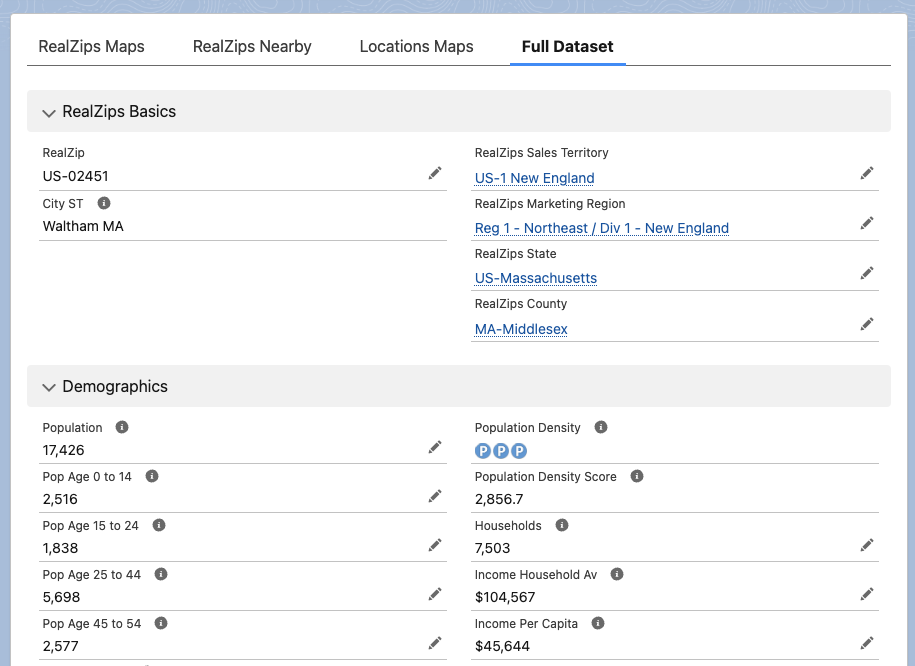
Use Case: RealZips brings Salesforce records to life by layering them with rich demographic insights from sources like the American Community Survey, IRS tax data, FEMA risk assessments, and CDC health metrics. This powerful geographic context enables nonprofits to pinpoint communities in need, make data-driven decisions, and maximize their impact.
2. Volunteer Recruitment and Deployment
Challenge: Effectively placing volunteers where they are needed most can be challenging, leading to inefficiencies, delayed response times, and missed opportunities to provide critical support.
RealZips Solution: Optimizes volunteer assignments based on ZIP code data, travel distance, and community needs.
Use Case: Identify nearby volunteers using a real-time distance search. Generate a ranked list by travel distance to streamline deployment, calculate reimbursements, and encourage volunteers to make the trip and provide their help.
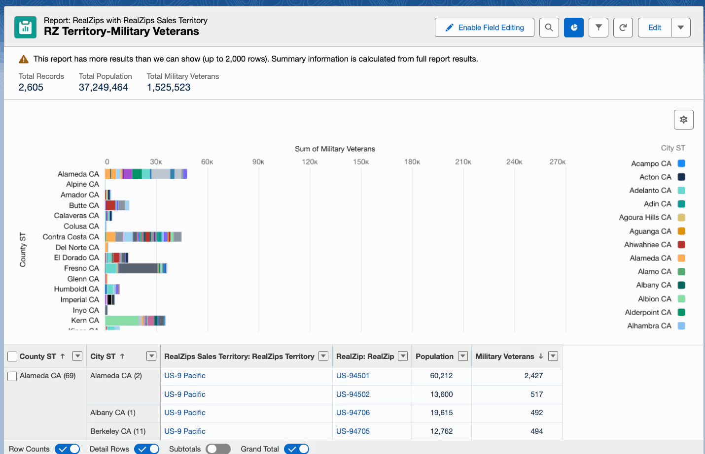
3. Donors and Fundraising Optimization
Challenge: Understanding where donors are located and identifying new fundraising opportunities.
RealZips Solution: Enhances donor segmentation by geography, enabling targeted fundraising campaigns based on giving patterns.
Use Case: Pinpoint donor hotspots by identifying areas with a high concentration of active and potential supporters. Use IRS charitable contributions metrics to benchmark and target ZIP codes with strong giving capacity and strategically plan fundraising events in these high-impact communities.
4. Program and Service Management
Challenge: Determining where to provide programs and services based on community needs and available resources.
RealZips Solution: Provides location-based insights to help non-profits identify underserved areas and allocate resources effectively.
Use Case: Identify communities that would benefit most from your nonprofit’s mission using data from the American Community Survey, CDC, IRS, FEMA, and other trusted sources. Pinpoint and tag ZIP codes where your efforts can drive meaningful, lasting impact.
5. Grant Management and Reporting
Challenge: Many grants require geographic reporting to demonstrate impact in specific regions.
RealZips Solution: Enables accurate tracking of grant-funded initiatives by location, simplifying reporting and compliance.
Use Case: With RealZips, nonprofits can track how grant funds are distributed across different communities. With RealZips, nonprofits can tag each grant-funded initiative down to a ZIP code level, local chapters, and service hubs , ensuring precise reporting on resource allocation. They will generate detailed impact reports, meet compliance requirements, and strengthen future grant applications with data-driven insights.
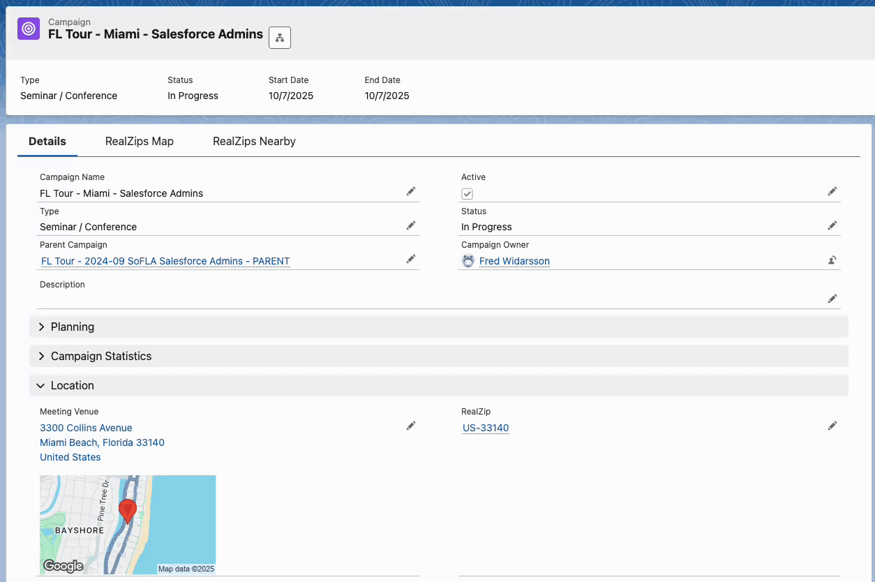
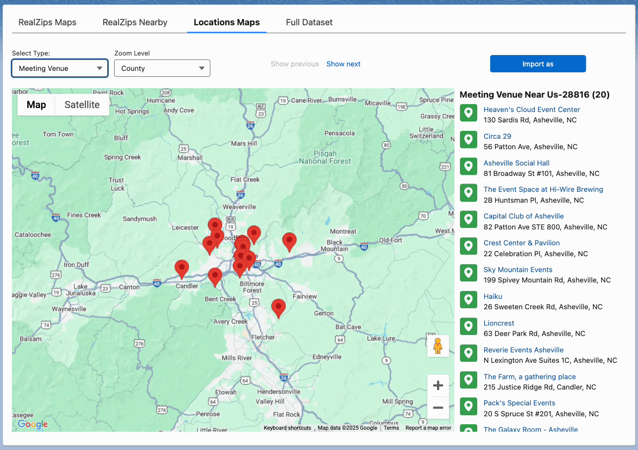
6. Event Planning and Logistics
Challenge: Organizing events in the right locations to maximize attendance and impact.
RealZips Solution: Helps map out ideal event locations based on supporter density and transportation accessibility.
Use Case: Nonprofits hosting fundraising events like galas, concerts, and walkathons can use RealZips to identify ideal locations based on supporter density. They can strategically choose venues to maximize attendance and donations by analyzing high-engagement ZIP codes. Whether for volunteer appreciation, awareness campaigns, or community outreach, RealZips ensures each event drives greater participation and impact.
7. Partnership and Collaboration Strategy
Challenge: Finding and managing partnerships with local businesses, government agencies, and other organizations.
RealZips Solution: Identifies potential partner organizations by region and industry to build stronger community networks.
Use Case: RealZips enables nonprofits to strategically manage partnerships within city, county, and state borders, as well as by proximity to partner locations. Its deep demographic insights help identify critical community needs—such as poverty, health disparities, literacy gaps, internet access, and food insecurity—allowing organizations to form impactful partnerships that drive meaningful change.
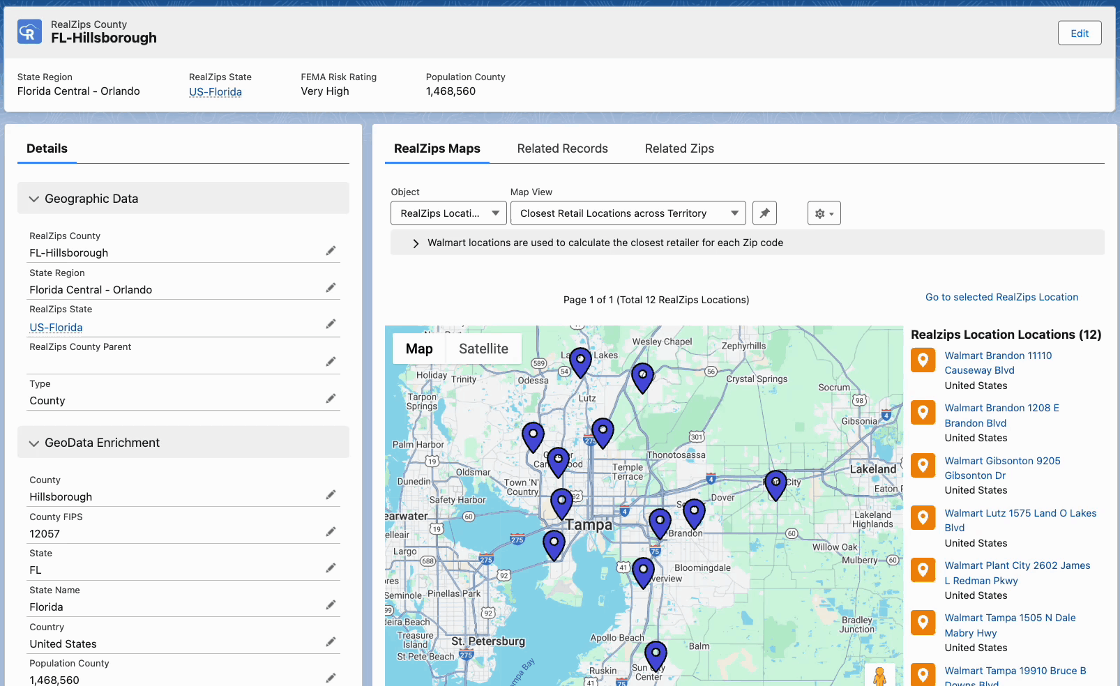
8. Crisis Management and Disaster Response
Challenge: Quickly mobilizing resources and coordinating response efforts in affected areas.
RealZips Solution: Facilitates rapid response by efficiently mapping out at-risk areas and directing aid.
Use Case: Nonprofits must act fast when disasters strike—whether wildfires in Los Angeles, severe flooding in Asheville, or hurricanes along the Gulf Coast. RealZips provides geographic insights, combining deep population data with FEMA vulnerability metrics to pinpoint the most affected communities. By flagging high-need ZIP codes in real-time, organizations can swiftly deploy aid, mobilize volunteers, and direct resources where needed. This data-driven approach ensures assistance reaches the right areas faster, improving response times and maximizing relief efforts.
Transform Your Nonprofit’s Impact with GeoData
From improving donor engagement to strengthening community partnerships and ensuring rapid disaster response, RealZips empowers nonprofits to overcome geographical challenges with precision. By integrating location intelligence into Salesforce, organizations can optimize outreach, better allocate resources, and expand services to the areas where they are needed most.
Nonprofits across sectors use RealZips to enhance impact with geographic and demographic insights. From education and healthcare to social services and community development, organizations can better allocate resources, optimize outreach, and engage donors. RealZips streamlines operations for relief efforts, mental health services, and veteran support, improving program delivery, volunteer coordination, and fundraising.
Let’s meet and explore the possibilities
Ready to see how RealZips can help your nonprofit maximize impact? Schedule a personalized demo to discover how geographic insights can enhance outreach, fundraising, volunteer management, and more.
We also offer resources to help nonprofits make the most of their Salesforce investment, including the Salesforce NPSP (Nonprofit Success Pack). Let’s collaborate to expand your reach and bring your mission to more communities.
Book a meeting with the RealZips team:
- Book a demo with the RealZips team: Set up a meeting here